Bone-Chilling Cold and a Looming Nor’easter: Boston Under Cold Emergency
Arctic Blast Grips the Hub
Bostonians are waking up to a city in the iron grip of a dangerous Arctic blast as Mayor Michelle Wu maintains a citywide Cold Emergency through today, Saturday, January 31, 2026. While the early morning sun might offer a deceptive glimmer of brightness, the reality on the ground is one of record-challenging temperatures and a looming threat from a powerful coastal storm. The city's emergency declaration remains active as officials urge residents to limit time outdoors and check on vulnerable neighbors during this period of extreme winter weather.
Frigid Morning Conditions
The day began with temperatures plummeting into the low single digits, with local sensors recording a low near 3°F. A persistent North-Northwest wind is making conditions significantly more hazardous, driving wind chill values down to a biting -11°F. Under these conditions, the National Weather Service warns that frostbite can occur on exposed skin in under 30 minutes. Most of the early morning hours will remain clear, though the intense cold will keep the streets of the North End and Back Bay quieter than usual for a Saturday.
Afternoon Sun Fades to Clouds
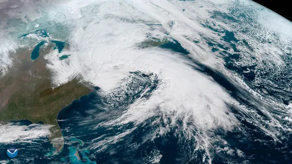
As we move into the afternoon, the sun will persist, but it will offer little relief. High temperatures are forecast to struggle to reach 20°F. Winds will remain steady between 5 and 10 mph from the Northwest. This period of afternoon sun is expected to be short-lived; by late afternoon, high-level clouds will begin to thicken as a rapidly intensifying low-pressure system moves up the Atlantic coast. This system, which meteorologists are tracking as a potential 'bomb cyclone,' is expected to bring significant impacts to New England starting late tonight.
Evening Storm Arrival and Safety Alerts
The evening forecast calls for a rapid transition. Overcast skies will take hold after sunset, with the chance of snow showers increasing significantly after 8:00 PM. While initial accumulation before midnight will be light—likely under an inch—the real danger lies in the strengthening winds and the transition to a major Nor’easter overnight. Coastal areas are under a particular watch for minor flooding during high tide cycles late tonight. The City of Boston has activated warming centers at various Boston Centers for Youth & Families (BCYF) locations to provide refuge for those in need.
Today’s Weather Summary
- Morning Temperature: 3°F with wind chills as low as -11°F.
- Afternoon High: Approximately 20°F with mostly sunny skies transitioning to clouds.
- Evening Outlook: Increasing cloud cover with snow showers developing late; winds beginning to gust.
- Current Warnings: Cold Emergency in effect; Coastal Flooding Watch for late-night high tides; Winter Storm Watch starting tonight.