Boston Braces for the Arctic Plunge: Bitter Cold and Dangerous Wind Chills Arrive Today
Arctic Air Grips the Hub
Bostonians waking up this Friday, January 23, 2026, are being met with a deceptive winter sun as a massive Arctic air mass begins its descent into New England. While the morning may start with mostly sunny skies, residents are advised that temperatures will remain dangerously low throughout the day, serving as a precursor to a record-breaking cold stretch and a significant winter storm expected later this weekend.
Morning: A Deceptively Bright Start
The early morning hours see temperatures hovering around 26°F, but with humidity at 42%, the air feels significantly sharper. Despite the presence of sunshine, the "feels like" temperature is already struggling to climb out of the high teens. Commuters should prepare for icy patches on side streets and platforms, as any residual moisture from earlier in the week has firmly frozen over. Winds are currently coming from the North-Northwest at roughly 10 mph, keeping the morning air crisp and unforgiving.
Afternoon: Clouds Build and Winds Quicken
As we move into the afternoon, clouds will begin to increase, obscuring the sun and allowing the Arctic front to tighten its grip. High temperatures are expected to peak in the mid-to-upper 20s, likely hitting a ceiling of 30°F. However, an increasing West-Northwest wind of 10 to 20 mph will make these temperatures feel closer to 10°F. The transition from a bright morning to an overcast afternoon marks the arrival of the coldest air the city has seen in several seasons.
Evening and Night: The Arctic Plunge
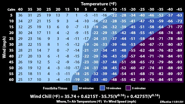
The true danger arrives after sunset. Temperatures are forecast to plunge rapidly on Friday evening behind a powerful Arctic cold front. By late tonight, air temperatures will drop toward a low of 3°F, with some suburban areas potentially seeing zero or sub-zero readings. The National Weather Service has issued a Cold Weather Advisory for the Boston area, effective from 10 PM tonight through 10 AM Saturday morning. Wind chills during this period are expected to reach a bone-chilling -20°F.
Official Alerts and Safety Notices
The city is currently under several active weather notifications that residents should monitor closely:
- Cold Weather Advisory: In effect from 10 PM tonight for the Boston/Norton coverage area. Wind chills as low as 20 below zero are possible. Frostbite can occur on exposed skin in as little as 30 minutes.
- Freezing Spray Advisory: Active for all marine zones starting Friday night, posing risks for local mariners as spray freezes on vessel surfaces.
- Winter Storm Watch: While today remains dry, a major winter storm is looming for Sunday, with predictions of 12 to 18 inches of snow.
Health officials urge residents to wear multiple layers, including hats and gloves, if they must be outdoors tonight. Ensure that pets are brought inside and check on elderly neighbors as the mercury drops into the single digits.