Slush and Snow: A Clipper Storm Complicates the Great Blizzard Cleanup
Overview: A Messy Wednesday Ahead
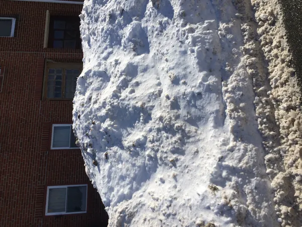
Bostonians waking up on Wednesday, February 25, 2026, are facing a complicated weather landscape. While the city continues to reel from the historic 'Blizzard of 2026' that dumped nearly two feet of snow across Massachusetts on Monday, a new 'clipper' storm is moving into the region today. This system will bring a mix of light snow and rain, threatening to turn the existing massive snowbanks into a slushy, heavy mess and creating treacherous conditions for commuters and cleanup crews alike.
Morning: Snow Returns to the Hub
The day begins with overcast skies and frigid temperatures in the low 20s. By mid-morning, approximately 9:00 AM, the clipper storm is expected to begin dropping light snow across the Greater Boston area. While the accumulation from this system is forecast to be relatively minor—likely less than an inch—the timing is poor for the morning rush hour. With many sidewalks still coated in packed snow from Monday’s record storm, the fresh layer of powder will obscure patches of black ice. Visibility is expected to be around 10 miles, but road conditions will remain hazardous as temperatures slowly climb toward the freezing mark.
Afternoon: Transition to a Slushy Mix
As we head into the afternoon, temperatures will peak at a high near 40°F. This warming trend will cause the morning snow to transition into a light rain and snow mix, tapering off completely by 1:00 PM. While the precipitation ends early, the warmer air poses a different threat: the massive piles of snow currently blocking drainage systems could lead to localized street flooding and significant slush accumulation. Southwest winds will pick up, gusting between 8 and 15 mph, adding a raw, damp chill to the air despite the higher mercury reading.
Evening: The Deep Freeze and Nighttime Clearing
By Wednesday evening, the clouds will gradually break, and the city will see decreasing cloud cover. However, as the sun sets, temperatures will drop back down to a low of approximately 29°F. This refreeze is a major concern for tonight, as any melted slush or standing water on untreated surfaces will turn into dangerous ice. City officials are urging residents to clear their nearby storm drains this afternoon to prevent overnight icing.
Forecast Highlights and Safety Notices
- High Temperature: 40°F (4°C)
- Low Temperature: 29°F (-2°C)
- Precipitation: 88% chance of snow/rain mix, primarily before 1:00 PM.
- Wind: Southwest at 8 to 15 mph.
- Alerts: Special Weather Statement in effect regarding slick roads and black ice during the morning commute.
- Recovery: A snow emergency remains in place as crews work to remove the massive totals from earlier this week.