Whiteout Monday: Historic Blizzard and 'Bomb Cyclone' Paralyze Boston
Morning: A True Blizzard at the Doorstep
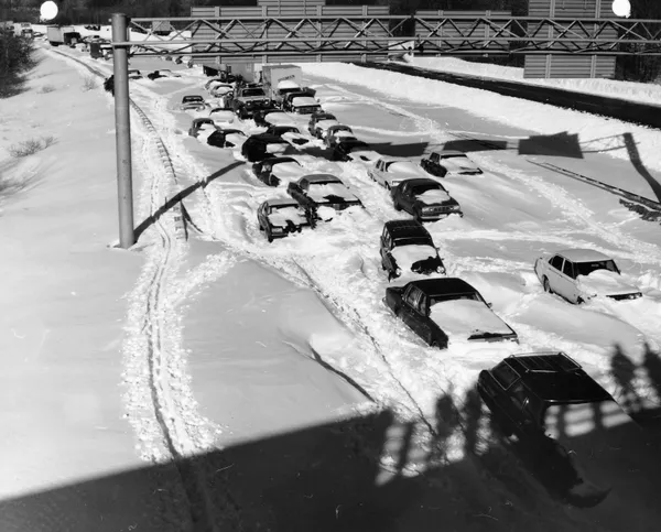
Boston residents woke up to a city transformed into a winter wasteland this Monday, February 23, 2026. A powerful nor’easter that underwent rapid intensification—known as bombogenesis—has brought the region to a complete standstill. As of the early morning hours, the National Weather Service has confirmed a full-on blizzard is in progress, with snowfall rates ranging between two and three inches per hour. Visibility in the downtown area and along the waterfront has dropped to near zero, making any form of travel essentially impossible. Morning temperatures are hovering around 32°F, but a biting northeast wind is making it feel closer to 19°F.
Afternoon: Peak Intensity and Dangerous Gusts
The storm is expected to reach its peak intensity during the midday and early afternoon hours. Forecasters are predicting total accumulations to reach between 20 and 25 inches by the time the system exits, with some localized drifts reaching even higher due to the extreme wind. Sustained winds are currently clocked at 25 to 35 mph, but gusts are reaching as high as 60 mph across the city and up to 65 mph along the immediate coast. These high-end winds, combined with the weight of heavy, wet snow, have triggered significant concerns regarding power outages. The temperature is expected to dip slightly to around 30°F by the afternoon, causing the snow to become lighter and more prone to dangerous blowing and drifting.
Evening: Tapering Snow and Coastal Flooding
By Monday evening, the heaviest bands of snow are projected to begin tapering off, though light snow showers will likely persist into the night. While the precipitation may ease, the danger remains high as temperatures are forecast to drop into the low 20s or even upper teens overnight. A Coastal Flood Advisory remains in effect, as the storm’s low pressure and high winds are pushing tides significantly above normal levels, threatening low-lying areas in East Boston and the Seaport with up to one foot of inundation.
Emergency Alerts and Safety Notices
A State of Emergency remains in effect, as declared by Governor Maura Healey, and Mayor Michelle Wu has maintained a citywide snow emergency and parking ban. All major campuses, including Boston University and MIT, are closed today. Officials are urging all residents to stay off the roads to allow plow crews to manage the massive snowfall. If you must go outside, be aware of the risk of frostbite and the physical strain of shoveling this heavy accumulation. Cleanup is expected to take several days as the city digs out from one of the most significant winter events of the decade.
- Expected Total: 20–25 inches of snow.
- Peak Winds: Gusts up to 60-65 mph.
- Temperature Range: High of 32°F, falling to 19°F overnight.
- Warning Status: Blizzard Warning remains in effect through 7 AM Tuesday.