Whiteout Warning: Nor’easter to Slam Boston with Heavy Snow and Damaging Winds
The Calm Before the Storm: A Critical Sunday for Boston
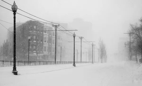
Boston is waking up to a quiet but tense Sunday, February 22, 2026, as a powerful nor’easter—described by meteorologists as a potential 'bomb cyclone'—intensifies off the coast. The National Weather Service has issued a Blizzard Warning for the city, effective from 4:00 PM today through Tuesday morning. This storm marks the first blizzard alert for the region in over four years, and residents are urged to complete all emergency preparations before the conditions deteriorate rapidly later this afternoon.
Morning and Midday: Overcast and Cold
The morning hours will remain relatively stable, though the air will feel increasingly biting. Temperatures are currently holding in the low 20s, with a projected daytime high of approximately 34°F. While no precipitation is expected during the early commute, the sky will remain overcast with a high humidity of around 85%. Light winds from the north at 5 to 10 mph will begin to shift and strengthen by noon. This midday window serves as the final opportunity for residents to secure outdoor furniture and gather necessary supplies before the arrival of heavy snow.
Afternoon Transition: Conditions Deteriorate
As we move into the late afternoon, the pressure will drop sharply. Around 4:00 PM, the Blizzard Warning officially takes effect. Visibility will begin to fluctuate as the first outer bands of the storm reach Eastern Massachusetts. While the heaviest precipitation is reserved for the evening, light snow and freezing mist may begin to slick the roads before sunset. Wind speeds will climb, with gusts reaching 30 to 40 mph by late afternoon, creating a significant wind chill that will make it feel as though temperatures are in the single digits.
Evening and Overnight: The Blizzard’s Full Fury
The core of the nor’easter is expected to strike between 7:00 PM and 10:00 PM tonight. During this window, snow rates could reach a staggering 1 to 3 inches per hour. This heavy, wet snow, combined with wind gusts projected to peak between 50 and 60 mph, will create life-threatening whiteout conditions. Travel is expected to be nearly impossible overnight, and officials are warning of high risks for power outages due to the weight of the snow on tree limbs and utility lines. Coastal communities are also on high alert for minor to moderate flooding during the overnight high tide cycle.
Forecast Highlights and Safety Alerts
- Temperature Range: High of 34°F; Low of 21°F.
- Wind Hazards: Northeast gusts of 50 to 60 mph, with higher gusts possible along the immediate coast.
- Snow Accumulation: 12 to 18 inches expected in the Boston metro area, with up to 2 feet in coastal pockets.
- Visibility: Near zero during peak evening and overnight hours.
- Travel Notice: Non-essential travel is strongly discouraged after 6:00 PM today.